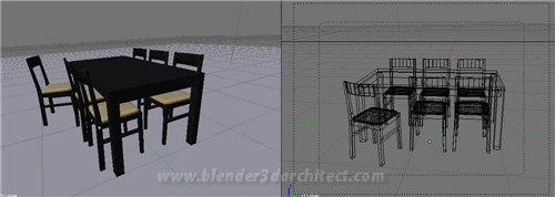
If you are going to work at a project, that involves architectural visualization, it will be very important to use furniture to humanize your renderings. There are two ways to deal with furniture models, for your 3d environment, you can either model all pieces of furniture, or find a good online library to download models to use in your scene. Of course, the second option is the easiest and the dream for every artist. But, sometimes we won`t find a specific piece of furniture to use, then you will have to model.
This time I won`t work with the modeling of a chair or table. But, I will point some nice resources to find furniture models to work with, and better yet, all of them are free to use.
So, here is the list:
- Resources blogscopia
- E-interiors (require registration)
- Blender Wiki for architecture
- LineDStudio
From all those resources, the best most complete to use with Blender 3d are Resources blogscopia and the Blender ArchWiki, which offer furniture models in the native Blender file format. All you have to do is Append or link the models to your scene, with no loss of data. The models available at Scopias Resource have their lighting and materials setup to work with YafRay, one of the best external renderers to work with Blender.

This an example of model from Resources blogscopia
The other links have furniture files in 3ds, obj, dxf and other file formats. With this other formats, we will have to import them to Blender, and it can result in triangular faces or small issues in the furniture model.
When we append or import the model in your scene, a lot of work will be required to setup the model. Because most of them doesn`t came with materials or textures. So, get ready to add some materials and textures to all models, but this is a task that I will cover on another article.
For now, be sure to gather as much links with furniture models, to use in your projects. They will be a great help to build a good scene.
Well, for sure these are not the only good resources to find furniture models, but they are great and I use them a lot.


Thanks
Hi,how are you, hope fine. Thank-you for letting try out the software, i’m looking forward for it.
Thank-you,
diane