Customize Consent Preferences

We use cookies to help you navigate efficiently and perform certain functions. You will find detailed information about all cookies under each consent category below.

The cookies that are categorized as "Necessary" are stored on your browser as they are essential for enabling the basic functionalities of the site. ... 

Always Active

Necessary cookies are required to enable the basic features of this site, such as providing secure log-in or adjusting your consent preferences. These cookies do not store any personally identifiable data.

No cookies to display.

Functional cookies help perform certain functionalities like sharing the content of the website on social media platforms, collecting feedback, and other third-party features.

No cookies to display.

Analytical cookies are used to understand how visitors interact with the website. These cookies help provide information on metrics such as the number of visitors, bounce rate, traffic source, etc.

No cookies to display.

Performance cookies are used to understand and analyze the key performance indexes of the website which helps in delivering a better user experience for the visitors.

No cookies to display.

Advertisement cookies are used to provide visitors with customized advertisements based on the pages you visited previously and to analyze the effectiveness of the ad campaigns.

No cookies to display.

Blender 4.2: Precise Modeling Workshop
Learning Resources →

The scales involved in a regular project for architecture hardly goes beyond a skyscraper or something like a shopping mall. But, at some point, you may have to extrapolate that and move to something like a full city. In that case, you probably will need some tool or resource to speed up the modeling of urban environments in Blender.

In a scenario like that when you must provide the visualization of large portions of a city, an Add-on that integrates Open Street Maps with Blender is a must-have.

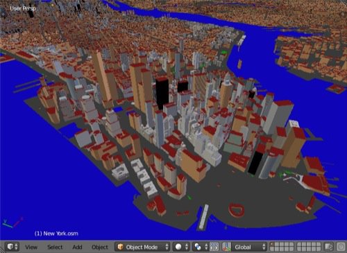
In the past week, I had to give advice to a small office that needed to work on an animation related to urban planning. It was mostly about traffic rerouting, but part of the project required an aerial view of the city. The quickest way to get that done was with the help of an Add-on created by a developer named vvoovv and shared at the Blenderartists forums.

Urban environments in Blender

With this particular Add-on, you can import OSM files straight to Blender. That makes the full process of working with the 3d modeling of the city much faster.

For projects related to urban environments in Blender, you will need a tool like this one. When you visit the link, just notice that there is a free and paid version of the Add-on.

After you have the OSM file in Blender, it will become just a matter of aligning the 3d models for the buildings with the proper streets. Much better than model all the roads based on bitmap data from maps.

Blender 4.3 for Complete Beginners (Workshop)
Previous

How to setup grass for the BGE

Next

Simple vegetation maps and models for architecture

Leave a Reply

This site uses Akismet to reduce spam. Learn how your comment data is processed.

Check Also

Clicky